2020 Rachel Carson Trail – East to West Run
Preparing For The Run
For the 2020 season I had originally planned to do four major races – Ironman 70.3 Chattanooga, Ironman 70.3 Musselman, Ironman Chattanooga and SwimRun North Carolina. In mid July, I was in my build for Ironman Chattanooga, when I got the news that the race was cancelled. That same day, I also heard that SwimRun NC was also being cancelled. All my 2020 races, were now cancelled and I had deferred my entry in all of them to 2021.
When I got the news about these last two races being cancelled, I was in by far the biggest training block I had ever done. I chose to finish that training block because, I wanted to see how my body handled the load and because it didn’t feel right to just quit working out.
A few weeks prior to the final cancellations, I could see the ‘writing on the wall’ and had started to think about what else I could do. I wanted a challenge that couldn’t be ‘cancelled’ and that is where the thought of doing a long trail run entered my mind. I could challenge myself to become an ultra-runner.
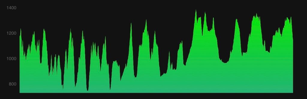
In Pittsburgh, the obvious trail run to do is the Rachel Carson Trail. Each year, on the weekend closest to mid-summer’s day, there is a race called the Rachel Carson Challenge, that covers about three quarters of the total trail. I thought to myself, I cannot do ‘The Challenge’ this year, but I could run that trail. I could do it on my terms and nobody could cancel it. I talked it over with my coach and in early August, we agreed to do it and to target the end of October for the big day.
This gave me about ten weeks to get ready. I needed to turn my Ironman fitness into trail running fitness. This involved significantly increasing run frequency at the expense of swimming and biking. It also meant starting to do some runs on trails. The build for the big day actually went quite well. I built up to over 40 miles a week of running and during those ten weeks, I was able to run sections of the Rachel Carson Trail to become familiar with it. I quickly learned that it was going to be a pretty epic challenge; mostly because of the elevation change and the steepness of some of the hills.
All was going really well until I woke up on October 14th with knee pain. This caused some changes to my training. My coach and I decided that I should rest my knee and effectively start a taper. We targeted the weekend of October 24th/25th for the run and I focussed on getting healthy.
A lot of foam rolling and some gentle stretching fixed my knee issue. As the weekend of the run approached, I monitored the weather and we decided Sunday October 25th would be the day. That was quite ironic, because that was the day I was supposed to be in North Carolina for my first ever SwimRun race.
Race Morning
I planned to begin my run at 7.30am, just after sunrise, and was therefore out of bed at about 4.30am. I had my standard race morning breakfast of a bagel and apple sauce and supplemented it with a couple of slices of toast. I was going to need all the energy I could take in to get through the day. I also had a couple of large coffees which helped me take care of ‘business’ ahead of my run.
The previous evening, my wife and I had packed the back of my car with everything we thought I would need. There were spares of everything, lots of food, lots of drinks and a couple of camp chairs. I had been warned about siting down during the run and the fact that I might not get back up, but I felt confident that I could do so.
We left home just after 6.30am and made the drive to the Eastern Terminus of the trail. We arrived just as it was getting light and I was all set to start my run on time. By now, I was getting really excited about the run. I felt confident that I could complete the just over 45 miles ahead of me, but I was also entering into the unknown. So many things could happen on the long day ahead.
My wife took a few photographs of me at the start to post on Facebook for our friends to see. I gave her a huge hug and thanked her once again for agreeing to be my support crew for the day. I took a deep breath, started both of my Garmin watches and took off up the gravel road. My day had begun.

The Run
Eastern Terminus to Saxonburg Road (5.5 Miles, 715 ft Gain, 910 ft Loss, 11:12 Pace)
The one good thing about starting the trail at the Eastern Terminus is that the first five miles are relatively flat. After a short climb away from Freeport Road, the trail enters Harrison Hills Park. The park features extensive woodland and very well used trails. This meant it was very easy for me to quickly get into a running rhythm.
The temperature was in the high thirties at the start of my run. I planned to run the whole route in a short sleeved run shirt, but with the cold start I chose to also wear arm warmers and gloves. Running through the park, I saw a couple of early morning dog walkers. Little did I know at the time, but these would be almost the only other people I would see on the trail all day.
As I got into my rhythm, I felt quite strong and also quite relieved. I had hardly run at all for two weeks because of my knee injury, and was worried about not ‘feeling it’ as I began the run. What I also noticed straight away was how many leaves had fallen since my last run on the trail. The deep leaf litter was somewhat obscuring the trail and was hiding underlying rocks and roots. This was going to be something I would deal with all day long. I had thoughts throughout the day about my run being ended by rolling an ankle on something I couldn’t see.
After three and half miles, I left the park, ran a short distance on a road and then made my way across land that is part of a horse farm. For the most part, this was very easy running, apart from a short very steep climb which I walked up. Power walking up the steep inclines was part of my game plan. I needed to keep my heart rate under control for the whole day and to conserve energy.
Eventually, I emerged onto roads again and enjoyed a very fast downhill section onto Saxonburg Road, where my wife was waiting for me. It was great to see her and she told me that a woman runner had left this parking area only five minutes ahead of me. She too was also attempting to run the whole trail today. I wondered if I would catch her up.
I took a quick drink of water, ate a raspberry jam sandwich, grabbed my hiking poles and set off. The hills were about to start.
Saxonburg Road to Bull Creek Road (4.2 Miles, 810 ft Gain, 990 ft Loss, 14:13 Pace)
This section begins with a long climb up a gravel service road that is quite steep. I walked up most of it, resisting the urge to run. I could have run up it, but I know it would hurt me down the road, so I stuck to my plan and walked. The route then traverses the ridge over to Burtner Hill East.
It was on this section, that I lost the trail for the first time. The trail is well marked with yellow blazes, but as I was running on a flat part of the trail, I decided to take a drink. When bending my head to drink from the bottle in my vest, I missed a turn. A while later, I realized I hadn’t seen a blaze in quite a while. Then, at the top of a small hill, I came across an unusual rock formation that I knew I hadn’t seen on my practice run. I immediately turned around. The detour had cost me maybe 3-4 minutes and had added about a quarter of a mile to my route. I was frustrated but was pleased that I quickly got my head around it and let it go.
Before long I was at the first very steep descent. The slope off Burtner Hill down to Burtner Road is over a 40% grade. I was so glad I had my hiking poles with me. Using them I was able to make steady progress down to the road, without slipping or overly hurting the muscles in my legs.
The remainder of the section is mostly in woodland that adjoins Route 28. On a map it looks quite flat, but in reality it is a series of short, sharp climbs and descents, as the trail crosses over numerous drainages (which thankfully were dry). This made progress quite slow at times. Running this section, I still felt strong. I was keeping up with my hydration, which was mostly an energy drink supplemented with water. I also ate a pack and a half of chews and some cookies.
As I descended to meet up with my wife at Bull Creek Road, I had not caught up with the woman ahead of me. The thought of trying to catch her crossed my mind, but quickly I reminded myself that this wasn’t a race, and I needed to stick to my own plan.
Bull Creek Road to Crawford Run Road (4.6 Miles, 1,150 ft Gain, 1,175 ft Loss, 15:15 Pace)
For me this is the most challenging section of the whole trail. Lots of elevation gain, lots of elevation loss, some very steep sections and almost no flat parts to actually run for any distance.
By now, I am fully into my long day. I have been running for a couple of hours, and mentally it is tough to realize that you are only a quarter of the way to the finish. With all the elevation change, I began to notice the first signs of some fatigue in my legs. Not bad feelings, but when you still have thirty miles of running ahead of you, you do start to question how the legs will hold up.
For nutrition, I started to dig into my stash of candy; I had chocolate and pretzel M&M’s. They tasted good and gave me a boost as I reached the small road part of this section on Bailey’s Run Road. The small sections of road running along the trail felt great. You do not have to worry about footing and could look ahead. Unfortunately, just under half a mile later it was back into the woods and up more hills.
The last half mile heading down to Crawford Run, is another really tough descent. It was very steep and the ground was quite unstable. It was small, loose gravel particles, which were like marbles under your feet. Even with my hiking poles, I slipped onto my butt at least twice. But I made it down safely and headed to see my wife in the Crawford Run Road parking lot.

Crawford Run Road to Springdale High School (5.0 Miles, 1,185 ft Gain, 965 ft Loss, 15:04 Pace)
After leaving the Crawford Run Road parking lot, the trail climbs about 400 feet in about a third of a mile. Initially, the climb is on a road, but about half way up, you enter the woods and it’s straight up a hillside with barely any switchbacks. It was a lung buster of a climb, followed by a short run downhill and back into another 150 foot climb. After this climb however, the next three miles were more undulating and run-able.
A good part of these three miles pass through Agan Park, and as I entered the park, I saw another runner waiting in the parking lot. It was my fellow through runner and she was waiting for her husband to arrive with supplies. We shared a couple of stories about our run so far, wished each other luck and I started running again. The run through the park includes a section on a bluff above the Allegheny River. I was nice to have a view other than just trees. As I was distracted by the views however, I landed awkwardly on a rock or root and rolled my ankle. I was able to ‘catch it’ before injuring myself, but it hurt and I admit to swearing rather loudly. Sometimes, it helps to be alone in the woods; there was nobody around to hear me cuss.
Soon, I could see the chimney of Springdale power station and I started the descent down to Freeport Road and the lowest part of the trail. I had a quick run along Freeport Road and then it was a long climb up the power line easement to Springdale High School. Once again, my wife was there waiting for me. She fed me exactly what I asked for and the cold Coke tasted great. Another quick hug and a kiss, and off I went again.
Springdale High School to Log Cabin Road (4.0 Miles, 465 ft Gain, 585 ft Loss, 13:18 Pace)
This is one of the better sections for actually running. Aside from a sharp descent to cross over Tawney Run and the ascent of Log Cabin Hill, you can run pretty much the whole time. On fresh legs, you can fly through these miles. I was now getting a little fatigued but I did run a lot and my pace improved a little.
After running along Tawney Run and then Yules Run Road, I face the long climb of Log Cabin Hill. After about a hundred yards of the climb, I started to cramp in the inner hamstring of my left leg. It got me very worried. I was only at the half way point and was getting a cramp! For the rest of the climb, I leaned hard on my hiking poles to avoid further strain on my left leg and fortunately the cramp went away.
I tried to think what might have caused the cramp. I had been hydrating well and mostly with my Infinit drink that contains plenty of electrolytes. I had stopped twice already to go to the bathroom, so I didn’t think the issues was hydration or electrolytes. I actually think it was fatigue and asking the muscles to do too much. After easing off, it went away and never came back all day.
As I descended Log Cabin Hill towards my next aid station and more food, I realized I was half way through. I was close to the overall pace that I thought I could run but equally, I was a little more fatigued than I expected.
Log Cabin Road to Emerling Park (4.1 Miles, 760 ft Gain, 755 ft Loss, 19:30 Pace)
This was the section of the run where everything changed. I had only run this part of the trail once before, and I couldn’t remember much about it. I had forgotten about the miserable climb up Lefever Hill, the run around the coal ash dump and the climb over Rich Hill. The whole thing was much harder than I remembered and it cracked me.
I was starting to hurt and I gave in all too easily to walking. I missed another turn on the trail and got sidetracked for several minutes again before turning around. I had to step aside for people riding dirts bikes. The descent to Deer Creek and Emmerling Park was painful and without the hiking poles, would have been ten times worse.
As I entered Emmerling Park, I heard a friendly voice behind me asking me how I was doing.. my fellow runner had caught up with me. We both complained about the pain, but it was good to see her and it lifted my spirits. The park was extremely busy with multiple soccer and baseball games happening. I was relieved to easily find my wife in the parking lot and equally delighted to see that our son had joined her.
During this aid break, I decided I needed to sit and re-group. That camp chair felt amazing but I knew not to be lulled into wasting too much time sitting there. I ate another sandwich, had some cookies and more Coke. I used a towel to wipe myself down and started to feel energized again. My fellow runner left the park ahead of me… I never saw her again.
Getting out of the chair was easier than I thought. I had run just under 26 miles so far and was about to go into new territory. I was about to enter the realm of the ultra-runner.

Emmerling Park to Cedar Run Road (3.0 Miles, 485 ft Gain, 400 ft Loss, 17:05 Pace)
Leaving Emmerling Park, the trail goes along Eisele Road for about three quarters of a mile. It is uphill all the way, but the grade is quite gentle for most of it. This was exactly what I needed. Running on the road, I realized that even though I was getting fatigued, I knew I was nowhere near fatigued enough to be concerned about finishing the run. My stride length was diminishing, but we every step I was making progress.
Leaving the road, I dropped down to cross Cunningham Run and then traversed the slopes towards Deer Creek. I crossed Saxonburg Boulevard and ran alongside Deer Creek, before making the steep climb up to the part of the trail that overlooks the Pennsylvania Turnpike. As you run along the bluff, the views are quite good and in the distance, I could already see my wife waiting for me.
The final part of this piece of my day was all downhill on a road. During my practice runs, I would absolutely fly down this road. Today I was much slower. Running downhill was starting to really hurt.
Cedar Run Road to McCully Road (2.5 Miles, 460 ft Gain, 100 ft Loss, 16:40 Pace)
Just like coming out of Emmerling Park, my run after the latest aid station stop was on an uphill road. This time the road was quite long, the longest on the whole route at 1.5 miles. I took off running at a reasonable pace but was struggling again. I felt like I was just shuffling along, rather than running. After a few hundred yards, I chose to start walking.
I am not sure what triggered me to start walking, but walking felt so good. I looked up the road however and said to myself, “this is close to the easiest section of the whole trail… why are you walking?” I realized that walking parts of the trail helped, but this was not a place to walk. I started running and told myself that I wasn’t going to stop until the next big hill stopped me.
The mile of running was tough, but in completing it without walking again, I had a huge mental win. I realized that I could still easily run the flatter sections. This would prove vital towards the end of the run. When I turned off the road, the trail became challenging again. I was climbing up to the highest point on the trail. At one point on the climb, I turned a corner and came face to face with five wild turkeys. As soon as they saw me, they ran away. I remember thinking that it must be nice to be able to run that fast.
As I approached my wife at the next aid station, I realized that I had not taken in any nutrition during this portion of the trail. I think I had drunk a little water, but that was about it. My appetite for food had completely gone away but I knew I needed to eat. Once at the car, I forced down some candy and some Coke, but that was all I could manage.
McCully Road to Topnick Drive (1.0 Mile, 180 ft Gain, 220 ft Loss, 17:50 Pace)
Heading into Hampton Township Park, I was now about three quarters of the way to the end. I knew the last quarter of the run would be very challenging. I would be well over any distance I had run before, so I made sure to increase the frequency of aid station stops. This wasn’t to enable more frequent eating but to give the mental support of knowing I would see my wife more frequently.
The run through the park was one long downhill, which I took slowly and one long uphill, which was also slow. I arrive at my car and said to my wife that I had completed lost my appetite. We were talking about some other things when she said .. “Would you like me to stop and get you some McDonald’s fries?”. I couldn’t say “yes” fast enough; that sounded exactly what I would like to eat. Knowing there would be fries at the next stop gave me a good boost. I set off and knew that I would soon have less than ten miles left to run.
Topnick Drive to Sample Road (2.40 Miles, 110 ft Gain, 440 ft Loss, 21:00 Pace)
I was slow on this part of the run. This was due to a couple of reasons.
The first reason was a gut issue that I needed to take care of. I had started feeling uneasy in the last few miles and now that I was running again, it was getting a little worse. It was not really that bad, but I chose to stop and take care of it. I lost maybe five minutes due to this, but it was well worth it. I felt better almost immediately.
The second reason was the long descent to Crouse Run. My legs were now hurting so much on descents, that I had to take them really slowly. Once by Crouse Run, I was able to run quite well again. I really like this part of the trail. Crouse Run is a really pretty creek and you get to cross through it four times. Luckily, the weather leading into my run was dry and so I was able to cross the creek using rocks and managed to keep my feet dry.
I emerged from beside the creek and ran quickly down Sample Road to meet my wife. She had those fries waiting for me.

Sample Road to North Park Dam (2.6 Miles, 360 ft Gain, 290 ft Loss, 16:40 Pace)
I was now getting close to very familiar territory. I was about to enter North Park. I have run more miles in North Park than almost anywhere else. Almost all these miles have been road miles, but I knew so many landmarks along the trail in this park.
The sky was starting to get darker now and there were one or two raindrops falling from the sky. The wind had picked up and I was stating to feel colder. As I ran up the South Ridge, I saw a couple walking their dog. It felt like I had returned to civilization. You will notice that I said that I ran up South Ridge. The feeling of cold had made me want to run to try and stay warm and run I did. Well I ran / walked up the hill and the running was slow, but I did run.
Further on, before running down to Pine Creek and the dam, I came across three mountain bikers. They told me they were lost. They look so relieved when I told them that they were a few hundred yards away from North Park swimming pool and pointed where to go. I guess that was my good deed for the day.
By now, I was struggling to drink but I knew I was hydrated because I had just been to the bathroom a mile or so back. I decided it was time to change up my gear at the next stop. At the parking lot next to the dam, I ate some more fries, had plenty to drink and took off my hydration vest. I was going to finish the run without it. I changed into a fresh running shirt and put on my high visibility yellow rain jacket. I also grabbed a couple of headlights; it was now almost dark. I had seven miles left to run.
North Park Dam to Eagle’s Nest Shelter (3.1 Miles, 385 ft Gain, 360 ft Loss, 20:20 Pace)
I was somewhat dreading the next two parts of the run. I had practiced a lot on them and knew that there was relatively little terrain that was flat. After leaving my wife, I did the long climb up to the top of North Ridge. I again managed to run/walk this hill and was also able to run a lot along the top of the ridge. What killed my progress however was the long descent down to Pierce Mill Road. The trail here is quite steep but also in quite rough shape. The footing was treacherous with lots of rocks and roots. It was now really dark and I was paranoid about turning an ankle. I didn’t want to have come this far and then fail by hurting myself.
I really took my time on that descent and made it safely to my next stop. I finished my fries, took another drink of water and smiled. I was on the home stretch; only four miles to go.
Eagle’s Nest Shelter to McKinney Soccer Complex (2.6 Miles, 325 ft Gain, 90 ft Loss, 20:05 Pace)
One last climb to do. I have done this climb several times before. I had done it so I was fairly familiar with the route. I wanted to have familiarity, because I suspected I might need to run it in the dark. Here I was running in the dark and guess what, the familiarity hardly helped at all. It looked way different in my headlight and I was running it a lot slower, so the landmarks I was looking for took longer to appear.
I spent a good deal of time stopped on the trail, second guessing myself. The trail on this section is not as well marked with blazes as other parts, so every time I found a yellow blaze on a tree, I breathed a huge sigh of relief. I ended up navigating well and didn’t miss a single turn. It just took me much longer than it should have.
I knew the wooded part of the trail ended with three switchbacks. These I did recognize quickly and was soon running across Bluebird Field and onto the road to the soccer complex. My wife was waiting, just like at every other stop. This time however, I didn’t hang around. I dumped my hiking poles and took a quick drink. The home stretch beckoned.
McKinney Soccer Complex to Western Terminus (1.4 Miles, 50 ft Gain, 200 ft Loss, 13:05 Pace)
I was off and running; really running. I suddenly found energy I didn’t know I had. The end was in sight. Three quarters of a mile along a really flat cinder trail, a short section of road and a quick descent through woods to the end. I could feel a smile come to my face. I couldn’t believe that I was going to actually do it.
The cinder trail section went by really quickly. I ran up the road to cross Route 19, passing by Wendy’s and the smell of more fries. Downhill to the entrance to the woods, where my wife greeted me with my hiking poles. Down the steep slopes through the woods. Across the Mirian Crossman bridge and there it was. The Western Terminus sign. I ran to touch it and stopped my watches.
I was done… 12 Hours, 44 minutes and 36 seconds after I had started.

Post Run
As I stood there trying to absorb what I had done, my wife appeared. I gave her a huge hug. I could not have completed the run without her. We took some photographs and eventually made our way back to the car. It was a very slow walk back up that hill to the car. When we got there our son was waiting for me too. He offered to go get me any food I wanted. I thought for a minute and said.. “I want fries, I really want some fries!”.